Our plane
GET BACK, Frank and Janet Around the Planet on the remote island of Rapa Nui, 4000 km from Chile or Tahiti, in the middle of the South Pacific Ocean, how good is that!
The airport
Rapa Nui aka Easter Island aka Pascua Island is a 5 hour flight from Santiago, Chile. It was named by Dutch Admiral Roddevan who landed there on Easter 1722. It was always called Rapa Nui by the natives. It is a triangle shape about 16 km in length and 117 Sq. Km In area. Average temp. Is between 18 and 23 degrees Celsius. The island was formed by three volcanoes that erupted and filled in the sea, thus the island is triangular in shape. In modern times there is a single airport runway, starting at the cliffs of the ocean at the Aero Puerto. The terminal is like a large Polynesian bungalow, small by airport standard but functional. First things first, before luggage is the purchase line for the National park ticket that allows access to all archeological sites. So virtually every one on the plane is in line, and this was a big plane, Boeing 787 with 9 seats across.
Our home stay in the rain
After we picked up our luggage we were greeted by our hostess, “Laura” Tuki Tepano Kaituoi, who transported us to her home on the family homestead, consisting of 4 separate dwellings for herself and son Jehielly, and her sisters and brother. In the museum we found a reference to Tomas, a talented artist and her brother. She calls the homestead “Hare O Ahani”. Hare is home in Polynesian, and Ahani is the nickname everyone on the Island called her father. I can't pronounce his actual name. This was our first “Home Stay” arrangement. We had a large bedroom with private bath, a separate eating area and kitchen privileges, which Janet likes to take advantage of. The home is on a main drive, walkable to the waterfront.
Frank with Lai
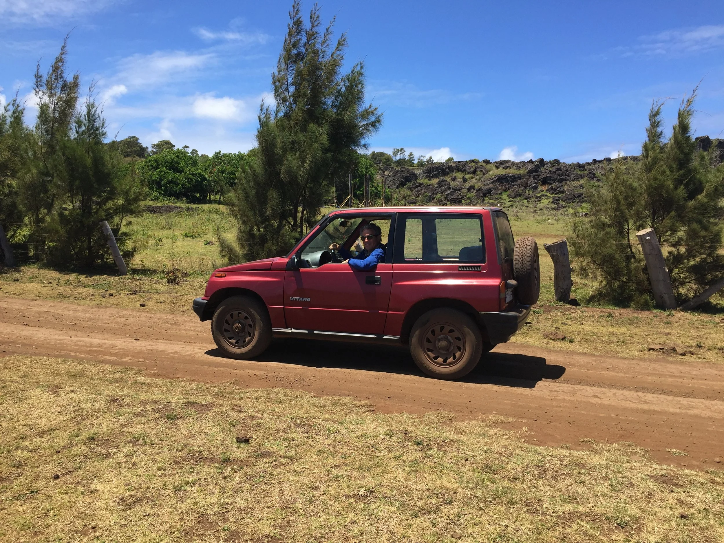
Frank with the Suzuki
We were also able to rent a car from her. On the island you can have any car you want as long as it is a SUZUKI SUV, with stick shift. Seriously, virtually all the vehicles are some sort of Suzuki, but there is no dealer. The cars are shipped from Valparaiso, Chile and unloaded by cranes on to barges or platforms. Our little SUV has 203,000 Km, and is fun to drive. I guess Janet having that little Fiat 500 with stick made the transition seamless. Having your own car adds to the thrill of finding the Archeological sites on the winding roads of the Island, many good roads but some dirt, pot holed and bumpy.
First day on island in the city
There is just so much to love about this Island. Breathtaking views of the vast blue of the pacific and the waves crashing into the black volcanic cliffs and shores. At first I'm surprised how calm the surrounding ocean is, but that changed over our time there because it went from brilliant sunshine for 2 days to overcast and torrential rains for 2 days. As a native said, the island is located in a sub tropical location so it rains all the time. The inland portion of the island has rolling hills and in some places rather high mountains, but not jagged. As you move away from the mountains toward the sea, there are sloping valleys interrupted by piercing bare faced black exposed volcanic rock which become monstrous cliffs near the shore. Another surprise, In the valleys, on the roads, near the sites, and just about everywhere you will see free roaming horses, alone or in small herds, also small herds of cows eating on the side of the roads. Apparently these are branded animals owned by someone, but not corralled. Just some beautiful stallions and we saw many babies with mom.
View of the sea
There is only one town on the island called HANGA ROA. The Current total population on the island is 3700. This includes Polynesian ancestors, Europeans and South Americans. We were told about 100,000 tourists visit the island each year. Historically, the island was populated by Polynesians starting about 800 AD to 1200 AD. It is not clear from which location they traveled. According to oral traditions, HOTU MATU, colonized the island and became the first king, aka ARIKI MAU. His six sons originated the the main tribes. There were at least 10 tribes organized into 2 sects at that time, high status on the west side and the lower status on the east side. His grandson, Miru, founded the most important tribe from which most ARIKI MAU came from.
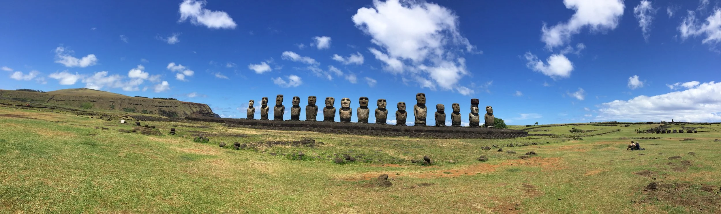
MOAI with top knot
The natives reference these first settlers as the “Short Ears”and there are some carvings of them. Then some years later there was a second influx of Polynesians that sported elongated earlobes, “Long Ears”. This second group merged with but took control of the island and are credited with the “MOAI” phenom, of huge figures, which have really long earlobes. This phase began after 800 AD and ended into the 17th century. These statues are just breathtaking. When completed, the figures wear carved top Knots of a red stone mined inland and also have inset wide open eyes of white stone and black or red stone. Only reconstructed sites have Moai with red top knots, and few have the eyes in place.
These Moai figures are displayed as respect for the leaders of the various tribes and were erected on the site of their villages. The oral history provides that each leader would commission his Moai to be completed prior to his death and upon his death it would then be erected on a platform called AHU. On various sites there are numerous Moai which indicate the longevity of the tribe and tribe leaders at that village. For example, If there was 4 Moai, it would represent that 4 leaders had lead the tribe until their deaths, which might span 200 to 300 years. At first the Moai were smaller and shorter, but eventually were carved into bigger and bigger sizes, probably at the leaders request if we know human nature. Supposedly, each Moai was stylized to reflect the leaders looks, but with erosion and abuse this is hard to see. However, different sized figures are often situated on the same Ahu. Unfortunately, that is only at Ahu at reconstructed sites because most of all the Moai on the Island have been toppled, cracked and broken, but make no mistake they are impressive. The history provides that civil wars arose between tribes and the victors would destroy the site. This situation is not blamed upon Europeans. Of the estimated 877 to 900 Moia on the island very few are standing upright. Apparently, it was French missionaries that first recorded the history of their observations of the toppling of the Moai by competing tribes, thus diminishing the spiritual power believed to be protecting the defeated tribe.. We thought it was interesting when told that the Spanish missionaries gave up and it was the French missionaries that worked to convert the island to “Catolica”.
The largest site of standing MOAI
The back of a site
The various large Moai range in size up to 11 or 12 meters in height and weigh up to 80 tons.
Erect Moia at the Nursery
One of the greatest mysteries on the Island is how were the Moia moved from the area of carving to the erection site at the Ahu. This could be a great distance, and really any distance with this weight was probably hard, but especially since there was only a single carving site with the formal name of Rano Rakuku in the center of the island. This spot is affectionately called “the Nursery”and has 397 Moai. This is the locale from where we all first saw photos of those magnificent faces of the Moai which were completed and waiting to be moved upon the death of a leader. Many are partially buried just to display the faces but not the longer body. At the Nursery there are many Moia figures only partially complete and still outlined in the mountain rock, and some just broken during bad transport or war. The biggest prospective Moia can be seen still cut in the rock never to be completed.
Moai not completed at the Nursery
There are different theories how the the Moai were moved. There is oral history about walking and also modern testing of hypothetical methods. One theory displays 3 ropes around the neck with 2 on either side pulled alternately to make the Moai walk, with the rear rope for support against falling. Another theory has the Moia rolled on wood logs greased by banana leaves replacing the rear log to the front as it rolls. Some tests have had the Moia on its back, or front , or even standing up, with or without platforms. All seem to work, but each have risks as 92 recorded fallen Moai on route to an Ahu demonstrate.
Cooking pit
Foundation of house
We are told there may have been as many as 18 Ancient tribes on the island, each with its own leaders and area of residential villages designated and protected by the Moai erected on the Ahu. These Ahu contained the “MANA” or life force protecting the Tribes. These tribes competed for natural resources from the 17th century and eventually conflicts broke out which led to the toppling of the Moai. The victors would install their leader as King, at least for awhile until the next conflict. We observed one of the larger territories on the west side of the Island probably governed by the higher status, starting from the city and extending along way down the coast. Called “ Ahutepeu”, it had many Ahu that signified long term control of the western waterfront. The village had many stone foundations for the housing shaped like a canoe, long, thin, and with spiking ends. The foundations had carved holes for wood posts to construct the walls and roofs of vegetable leaves. There were ceremonial cooking pits called “UMU” created by volcanic rocks walls. The fire charcoal and food would be covered by banana leaves and dirt and then grass sod to create an oven. These canoe shaped homes and food pits, of various sizes, are found at all the village sites.
Site of the bird man competition
The politics, religion, and society of the Island gradually changed after the tribes tired of fighting during the period of carving the Moai. The “Birdman Cult” arrived from around the 17th century until 1864, before the missionaries came! The tribes adopted the Creator God of Humanity called “MAKE-MAKE”, who was above all other gods. Similar to the TANE God of Polynesia. They would annually have a completion, like olympics, where each tribe had its designated champion search for and secure the first sea gull egg, called “Manutara “egg, of the spring season from the nearby small island of Motu Nui, which he would deliver to his leader. That leader would be named King or “ Tangata Manu” of the entire Island for 1 year. The Tangata Manu stays at either of 2 places, at the ceremonial village, ORONGO,, at the cliffs of the great inactive volcano crater called “RANO KAU”. Here the houses are all rock tiles but as usual in the shape of canoes. We were there and can say this Crater is magnificent with its own ecosystem of plants and animals, but the wind is really high. He may also stay at the wonderful beach community at ANAKENA, which we also saw enjoying the warm water and reconstructed Ahu with Moai that had top knots and affixed eyeballs. The Tangata Manu is attended only by other holy men. The natives drew many Petrographs in the rocks in deference to this cult, usually referencing Make-Make, Manutara birds and other natural creatures. There were, however, still conflicts between some tribes that did not want to accept the new Tangata Manu, so war did continue at time and harsh reprisals levied. The competition was stopped by 1867.
The crater
Eventually, the penetration of the Europeans reduced the native inhabitants to 110. Some had been enslaved and moved elsewhere, others left on there own accord. For many years the natives were congregated within the city boundary while the Island was controlled by Chile as a sheep farm aka “estancia”.
The natives regained full access to the island in 1960’s and are reinvigorating their culture, which includes the annual Tapati Rapa Nui Festival where Polynesian type competitions are pursued. These include triathlons to canoe, run and swim the smaller crater lake at the Nursery, ski or slide down large hills on banana leaves, and dance and singing competitions.
The island now has an active Chamber of Tourism and tourist dollars reach $250 million per year. We are glad we could contribute.
Below are some additional photos to share
Frank inspecting a head
Frank in cave
Janet in cave
Another village site
Top knot
Broken head due to tribal war
Another site also with house foundation
Large site on water
Site on beach
Good mana spirit
Historic dig that shows length
Original eye